
Reno's Doubleheader Wildfire Day
June 11, 2024, marks Washoe County's first two 100+ acre wildfires of the season.
Dual Firefighting Efforts
In a jarring start to the wildfire season, Washoe County experienced its first wildfire (over 100 acres) of the year, shortly followed by its second later in the same day on Tuesday, June 11, 2024.
The Trail Fire was first reported at 3 p.m. on Tuesday near Red Rock Road just west of Highway 395. Heat and steady winds propelled the fire upwards on Peavine Mountain in an area that is no stranger to wildfires during the summer months.
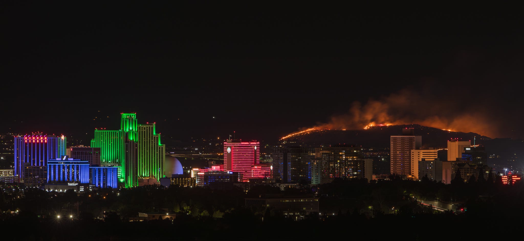
While firefighters were still battling the Trail Fire, another blaze erupted six and a half hours later in a more urban area. The Sullivan Fire was first reported just north of Hug High School, next to the Wildcreek Golf Course at 9:30 p.m.
Since this new wildfire started at night in a prominent location visible from Reno and Sparks below it, many onlookers raced towards it to check it out. This caused reports of several vehicle crashes as onlookers drove distracted near the emergency area.
Area firefighting resources faced a test as they responded to both wildfires concurrently.
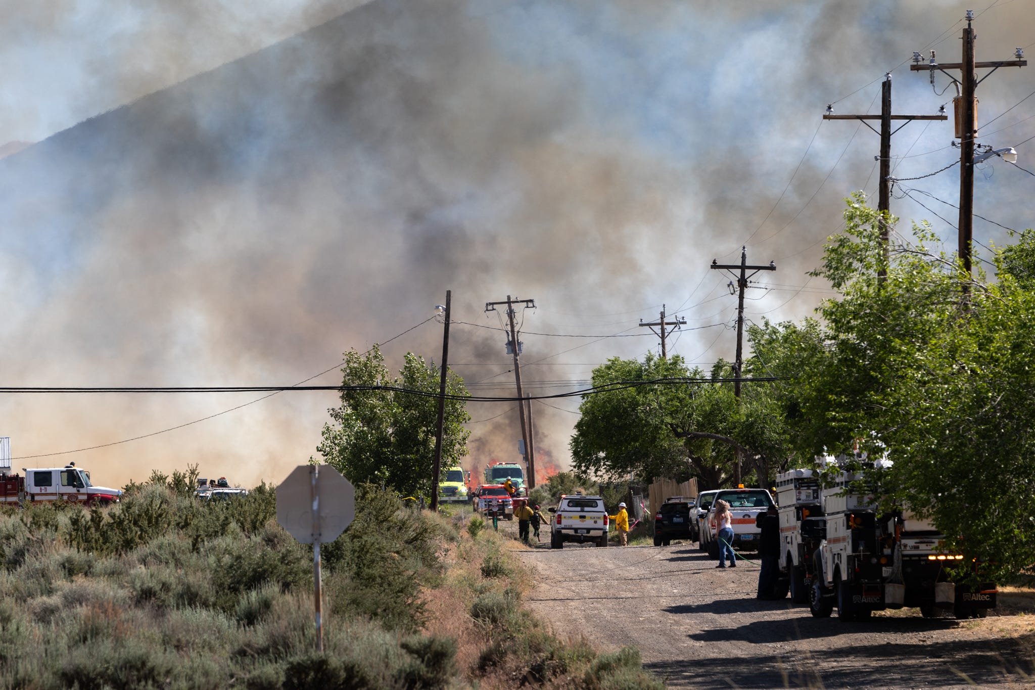
Firefighters appeared to tame the fires at both sites quickly, however, they issued evacuation warnings to nearby neighborhoods at both wildfires as a precaution.
There were no structures lost in either of these wildfires.
Firefighters fully contained the Trail Fire within 48 hours and mapped it at 195 acres, while they fully contained the Sullivan Fire 12 hours after the first report and mapped it at just under 140 acres.
Above Average Temperatures for Early June
Following last week's record-breaking heat, Reno was once again in the midst of another heat series when these wildfires occurred, with temperatures sitting at 98 degrees Fahrenheit at the onset of the Trail Fire.
The initial data logged during the Trail Fire data shows Reno experiencing a relative humidity reading of 15%, as well as wind speeds maxing out at 23 mph gusts.
These numbers can get worse when fire season starts in earnest, with Reno often experiencing sub 15% relative humidity numbers and wind gusts over 30 mph in the summer months.
High winds and low relative humidity create perfect conditions for wildfires to spread rapidly.
Forest agencies and the National Weather Service use relative humidity, wind speed, high temperatures, potential lightning, and 7-day fuel dryness levels to determine when to conduct prescribed burns safely and when to communicate red flag warnings to the public.


Comparing 2023 vs 2024 at the Start of the Season
California and Nevada benefited from a wet winter before the start of the 2023 wildfire season, which contributed to a shorter and less intense fire season overall.

Total acres burned in 2023 were dramatically lower than the five-year average as seen in the graph above.1
Entering 2024, both states are once again coming out of an above average snowpack season, however the snowpack difference from April 1, 2023 compared to April 1, 2024 is extensive.
Snowpack can reduce the possibility of large fires growing early in the season, providing more moisture in the vegetation for longer periods of time and preventing extreme fire behavior until mid to late fire season.
Snowpack on April 1, 2023: 232 percent of normal
Snowpack on April 1, 2024: 108 percent of normal
The outcome of this year's wildfires remains uncertain, but the abundant vegetation resulting from an above average snowpack in combination with a reduced number of prior year fires may serve as a significant fuel source.
Alternatively, the outcome could be a repeat of 2023, which would keep the number of acres burned by wildfires low.
How significant is the 2024 reduced snowpack, which is still above average, impact wildfire behavior compared to 2023’s deep snowpack?
Time will tell.
Resources to Use for Tracking Wildfires
Watch Duty App: This is an app that’s run by volunteers contributing real-time information from official sources and radio communications during wildfires.
Nevada Wildfire Information Dashboard: Nevada wildfire mapping and informational tool.
Nevada Fire Info: Real-time updates for wildfires in Nevada and general fire prevention information. Includes links, fire cams.
AirNow: Interactive map of air quality.
National Interagency Fire Center. (2023). Annual Report 2023. Retrieved from https://www.nifc.gov/sites/default/files/NICC/2-Predictive%20Services/Intelligence/Annual%20Reports/2023/annual_report_2023_0.pdf